Restricted By-Way/Definitive map query (pics)

autumn7

Well-Known Member
Joined
1 January 2010
Messages
403
Visit site
I’ve been riding a local Restricted By-Way for nigh on 25 years. It’s a track half a mile long linking two minor roads. The landowner dislikes the route being used and for many years has a padlocked metal barrier at one entrance with bricks and rubble within long grass at one side of the barrier to prevent squeezing through. If the barrier happens to be open for farm vehicles (rarely), I’ve ridden through it. Several years ago the land owner saw me at the barrier. I asked him if he could unlock it to let me ride through. He was hostile, saying it wasn’t a right of way for horses. I was insistent and after an unpleasant few minutes he ungraciously relented and unlocked the barrier, let me through, then locked up again. It was an unpleasant experience and one I wouldn’t wish to repeat.
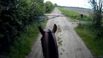
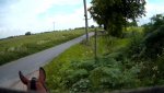
Roll on a few years…I’ve continued to ride along if the barrier is open but have always felt as if I’m trespassing. Until last month. The barrier now appears permanently padlocked shut and a sign has appeared. (see photo)
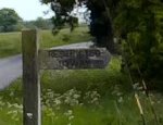
I need to seriously broach this before I lose this route for ever. I have now got a copy of the definitive map just to double check that this IS indeed a right of way for horse riders, to discover this route is marked thus; (see 'marking on definitive map' photo below).
Now I’m unsure. Am I entitled to ride this route (marked Restricted By-Way) or not?

18 May 19 b_Moment (3).jpg
Gate with sign
18 May 19 b_Moment(4).jpg
Restricted byway sign
DSC01482 (3).JPG
Marking on definitive map
 

Attachments

  • 18 May 19 b_Moment (2).jpg
    18 May 19 b_Moment (2).jpg
    527.9 KB · Views: 43
  • 18 May 19 b_Moment(3).jpg
    18 May 19 b_Moment(3).jpg
    455.7 KB · Views: 29
  • 18 May 19 b_Moment(4).jpg
    18 May 19 b_Moment(4).jpg
    41.9 KB · Views: 28
Last edited:

autumn7

Well-Known Member
Joined
1 January 2010
Messages
403
Visit site
Neddy man - Apparently CRF translates as 'Road used mainly as a public footpath' - according to the definitive map reference. This is why I'm querying my right to ride it in this day and age. The definitive map also shows some routes marked as CRB, seemingly 'Road used mainly as a public bridleway'.
Can anyone with definitive map knowledge enlighten me?

Gift horse - thanks for your pdf info...and dogatemysalad...I shall, now I've got the ball rolling, although did want to ensure my use of the route was legit first. Once I'm certain the next step will be how to get the route unbarred as the padlock totally prevents it's use. At least cyclists and pedestrians can scramble underneath, not that they should have to.

And Amy...feel free...no locks on my thread...!
 

Micky

Well-Known Member
Joined
11 July 2013
Messages
1,664
Location
Top of the world
Visit site
From google, restricted byway is not open to motorised vehicles, it isn’t probably the reason for the gate but I think maybe by law, there should be a gate for a horse rider to go through, but best ringing your local council and asking them for definitive and telling them your problem.
 

Gloi

Too little time, too much to read.
Joined
8 May 2012
Messages
11,380
Location
Lancashire
Visit site
Go onto your council website where there should be somewhere to report problems with rights of way, and report it to them, both that it has been blocked and that you have been intimidated from using it.
I have reported a local right of way recently, I filled in the form on the website, and got an email back. Some time in the future I expect to get an email back with a report of what is being done. From experience they tend to act on instances of the row being deliberately obstructed pretty quickly, sometimes with a nice new gate and sign, but there is a local one blocked due to flood damage that has been shut for 2 1/2 years waiting for funding to fix it.
 
Last edited:

little_critter

Well-Known Member
Joined
20 June 2009
Messages
5,833
Visit site
Neddy man - Apparently CRF translates as 'Road used mainly as a public footpath' - according to the definitive map reference. This is why I'm querying my right to ride it in this day and age. The definitive map also shows some routes marked as CRB, seemingly 'Road used mainly as a public bridleway'.
Can anyone with definitive map knowledge enlighten me?

Gift horse - thanks for your pdf info...and dogatemysalad...I shall, now I've got the ball rolling, although did want to ensure my use of the route was legit first. Once I'm certain the next step will be how to get the route unbarred as the padlock totally prevents it's use. At least cyclists and pedestrians can scramble underneath, not that they should have to.

And Amy...feel free...no locks on my thread...!
Surely 'mainly used as a footpath' just describes how it's mostly used. It doesn't limit what CAN use it. It's like saying roads are mainly used by cars...doesn't meant bikes are not allowed to use them.
 

autumn7

Well-Known Member
Joined
1 January 2010
Messages
403
Visit site
Thanks everyone. Just logged on and you've all been very helpful.
Tiddly, Neddy and Marmalade - thanks, I do have an OS map and it's marked as a Restricted Byway.
Thanks Follys, but I'm Norfolk so not on that list.
Little critter, my thoughts exactly. I see it as 'not exclusively used as a footpath' too.
Gloi, I did in fact complete a form online at the time of the altercation with land owner but never received a response. Weeks went on and I just gave up on it. I shouldn't have.
Leo - this track would be perfect for a carriage. I've never seen anyone else trying to use it, on horseback or otherwise so I think I'm fighting a lone cause. Shame as there's strength in numbers.
Terrier,Micky and Meleeka - I'm about to phone BHS right now to find details of the access officer for this region and shall seek their advise. I shall keep you all posted.
 

autumn7

Well-Known Member
Joined
1 January 2010
Messages
403
Visit site
Quick update; just spoken to lovely lady, Rachel, at BHS Access Dept. She's taken details to forward to my area access officer (she needs to see who is the nearest) who will be in touch in due course.
First steps and all that.....Thanks for the support everyone. There will be news flashes as things (hopefully) progress!
 

Leo Walker

Well-Known Member
Joined
19 July 2013
Messages
12,384
Location
Northampton
Visit site
Bing maps has an option to use ordance survey maps and its so useful for looking up ROW.

Just realised that that links to bing maps, that will teach me to look at things properly first!
 

autumn7

Well-Known Member
Joined
1 January 2010
Messages
403
Visit site
For those that took an interest in the locked barrier predicament, I'm thrilled to report the problem has been solved. Happy days! The bridleway is now rideable, thanks to the brilliant efforts of the County Council Highways Dept who took my issue seriously from the onset. I was asked to provide details and photos forthwith. It was agreed that blocking the entrance in this way was illegal and the landowner was contacted by them and asked to remove the rubble and chop down growth to one side of the locked barrier to enable horses to pass safely. If this was done the barrier could remain padlocked. However, if this didn't happen or they were confrontational about it, then the barrier would be removed.
Five weeks on and this has been done. Tomorrow I am looking forward to a leisurely circular hack taking in this piece of bridleway and as I do so, I shall be thinking of all you helpful forum members who gave me the shove to do something about it. Thank you all!

Just to add, the help from the BHS Access Dept which initially sounded promising came to nothing. Having spoken to Rachel who sounded on the ball, I received an email from an access bod in a neighbouring county telling me she would pass my message on to someone nearer to me. I've heard nothing since. Moral of this tale I guess is that if you have a problem with a bridleway and need an outcome, consult your County Council rather than BHS, even if you are a Gold Member!
 
Top